The Republican landscape reserve “Stronga”
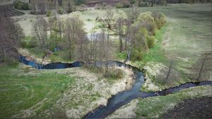
Back in 1996, the first ichthyological wildlife reserve in Belarus called “Stronga” with the total area of 6,991 hectares was established in the western part of Baranovichi district. Its main aim was to preserve the habitat of the endagered species of brook trout (in Belarusian – stronga) and protect the precious natural complexes.
Brook trout (Salmo trutta trutta morpha Fario (Limnaeus, 1758 ) is entered into the Red Book of Belarus as an endangered species whose salvation is impossible without taking certain measures. This variety of fish is very sensitive to modern anthropogenic changes in nature. Brook trout is very particular about the habitat conditions, it can’t tolerate even a small amount of contaminants in water, therefore it is a recognized indicator of pure natural waters.
In October 1998, by the decree of the Council of Ministers of the Republic of Belarus No. 1634, the Republican landscape reserve “Stronga” was established.
The reserve “Stronga”, whose total area is 12,015 hectares, lies in Baranovichi district, Brest Region.
The territory of the reserve consists of 2 isolated sections. The first section “Issa” is within the range of the Issa river catchment area, near the village of Polonka. The other “Lokhozva” is to the south of the highway Baranovichy-Slonim.
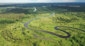
The river Issa with its tributary Polonka and the river Lokhozva with its tributaries Derevianka, Detkovka, Basiny, Zherebilovka, Kocheryshka, Ryzhovka and Studenka run on the the reserve. The rivers are mainly fed from underground by ground water discharge. The water has high organoleptic qualities.
The area of the reserve covered with forest makes up 74 per cent.
Natural landscapes are well preserved on the larger part of the reserve. A considerable section of the river Lokhozva basin where the trout is found lies within the range of Obuz-Lesnovsky military firing ground which is closed for civilians as it is under special guard which ensures preservation of natural landscapes.
The whole territory of the reserve is of various zoological and botanical interest. Here meet the borders of geobotanical, meadow, marsh, pedogeographical and zoogeographical areas, which determines the wealth of fauna and flora.
The general ecological significance of the basins of the rivers Lokhozva and Issa is that they serve as a buffer between the areas of intensive anthropogenic activity, including the agricultural one.
Geographic coordinates:
Area «Лохозва» N 53° 01' 08,19" E 25° 38' 36,03"
Area «Исса» N 53° 06' 54,23" E 25° 41' 07,94"
Foto: Владимира ЗУЕВА


